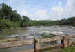
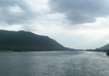
Netravati River
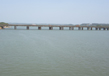
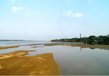
The Netravati River is originated in Karnataka’s Chikkamagaluru district and is considered as one of the sacred rivers of India. It is also called as “Nethravathi”. It runs through popular pilgrim place Dharmasthala and it merges with the river Kumaradhara before merging into the Arabian Sea. When it flows from Uppinangadi, it reaches the Mangalore city and it is the main water resource to Mangalore and Bantwal. One of the major gateways to Mangalore is the railway bridge constructed on the Netravati River. The Netravati River has the longest railway bridge made on the top of the river bank. The cities nearby Netravati River is Bangady, Ishaq Indabettu and Nellyady Town. A small boat can be used to navigate river Netravati. The town of Bantwal is located on the banks of the river and hence till early last century the river was known as Bantwal River. The town of Bantwal often inundated due to the spillover of river Netravati in the monsoon season. The years 1974 and 1928 had major floods due to the overflow of the river.
A diversion project on Netravati River is being proposed which will have the river flowing to eastern parts of the Karnataka State. As per the experts, the diversion will have an ecological, cultural and economical impact on the economy. The expert also states that river is a living thing and its movement to another direction will impact the environment as it is against the nature’s laws. The diversion project wants the river to direct to the Yettinahole area in the Western Ghats upto Chikballapur and Kolar districts in east as mentioned by the State Government.
Course
The Netravati River exhausts an area of 1353 square miles which start off in Yellaner Ghats in Netravati River Bangrabalike forest land.
Occupation - Agriculture & Fishing
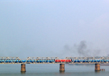
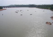
As Netravati river’s water is the main cause of farming, the people staying near the banks of rivers end up doing agriculture. The river is very famous and prosperous and fishing is done by people settled on the banks. Hence, Fishing becomes their opportunity to earn income. Fine sand is present on the banks of the Netravati River, people do business of sand which is further used for construction purpose. The bed of the river throws away this sand which is smooth. The river bed is very smooth, but consists of hornblende rock on the bed. The catchment area of Netravati River is acknowledged as one of the 30 hotspots for the world’s bio-diversity conservation project. The project aims at creating a lot of inland waterways or canals for nearby villages such as Hongada Holae, near Shiradi, Keri Holae, Yettina Holae and Yedakumeri. On the waters of the Netravati river more than 40 Lakh people survive for their daily needs. Paddy fields are grown by seven lakhs farmers on the 35,000 hectares of land near Netravati River. References of Netravati River are mentioned in a book called “Gazetteer of Southern India” which was published in 1855. The book was written by Pharoah and Co and other writers. The book mentions the river is not affordable during the South West monsoon.
Tributaries
The Netravati River has several tributaries which ensure greenery everywhere all the year. 38 reservoirs are formed by ancillary’s which are spread over the region. To meet the irrigation needs the existing river water is proficiently supervised resulting in water flowing from tributaries like Hemavati, Cauvery and many others.
Related Image
Also Browse Following Under This Section
Rivers
Related Topics
agara-lake
The agara-lake is a famous artificial lake which has its location 20 km away from the Hyderabad city in the....
Ntr Gardens
ayyanakere-lake is a very famous delta that is situated in the Andhra Pradesh in district of East Godavari. Water has surroun....
Shamirpet Lake
Shamirpet Lake is a man made or artific...